
{{product.productLabel}} {{product.model}}
{{#if product.featureValues}}{{product.productPrice.formattedPrice}} {{#if product.productPrice.priceType === "PRICE_RANGE" }} - {{product.productPrice.formattedPriceMax}} {{/if}}
{{#each product.specData:i}}
{{name}}: {{value}}
{{#i!=(product.specData.length-1)}}
{{/end}}
{{/each}}
{{{product.idpText}}}
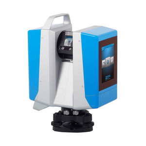
... highly accurate results even with long distances. The terrestrial laser scanner Z+F IMAGER® 5016 is equipped with an integrated positioning system, which allows the automatic registration in the field, ...
Zoller + Frôhlich

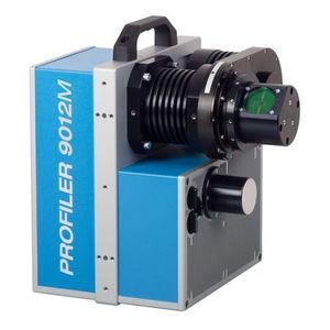
The Z+F PROFILER® 9020 is a highly efficient 2D laser scanner for mobile mapping applications. The rotation speed of the Z+F PROFILER® 9020 is 267 Hz or 16,020 rpm max.. It measures up to 182 m and has a very high data ...
Zoller + Frôhlich

... objects are registered and processed by the software. Because the laser measurement system corresponds to laser class 1, the scanner can be used in urban environments without any restriction. A hardware-assisted ...
Zoller + Frôhlich
... objects are registered and processed by the software. Because the laser measurement system corresponds to laser class 1, the scanner can be used in urban environments without any restriction.A hardware-assisted pixel-by-pixel ...
Zoller + Frôhlich
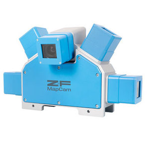
... view and a high dynamic range with images. Combined with the MapCams they cover the whole measuring area of the 2D laser scanner. The camera S+ is exactly matched to the basic camera C , fully compatible with them ...
Zoller + Frôhlich
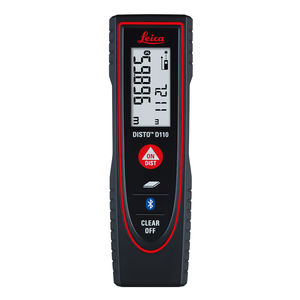
Leica DISTO™ - the synonym for laser distance meters. Easy handling, precise measuring results and suitable measuring functions make the Leica DISTO™ the ideal helper for measurements. Handy, simple, precise! At the touch of a ...
... streamlines the reality capture process thereby opening this technology to non-surveying individuals. BLK360 Imaging Laser Scanner Allows you to scan in high, standard and fast resolutions Weighs 1kg / Size 165 ...
LEICA PRECISION TOOLS BY LEICA GEOSYSTEMS

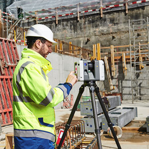
... and find new business opportunities, Leica ScanStation P50 is the fastest and safest, long range 3D laser scanner. Unlike any other laser scanner, the P50 solution maximises productivity by scanning inaccessible ...
LEICA PRECISION TOOLS BY LEICA GEOSYSTEMS

... durable 3D laser scanners perform even under the toughest environmental conditions, such as extreme temperatures ranging from – 20°C to + 50°C and comply with the IP54 rating for dust and water resistance. Leica Geosystems ...
LEICA PRECISION TOOLS BY LEICA GEOSYSTEMS
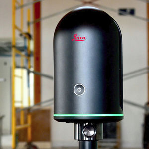
... the field and in the office through fast, simple-to-use, accurate, and portable hardware and software. The RTC360 3D laser scanner is the solution for professionals to manage project complexities with accurate and reliable ...
LEICA PRECISION TOOLS BY LEICA GEOSYSTEMS
Take full advantage of the features offered by XAtlas with QR Box! QR code and barcode Optical reader Adjustable inclination QR Box is the new add-on reader with optical technology, compatible with all the terminals in our ...
Please specify:
Help us improve:
remaining